
The saltmine has kept me from SOTA and playing radio in general, but when I told the XYL in March that the long weekend in June would be a SOTA weekend she agreed. She probably needs the quiet time as much as I do 😉
The months and months between March and June saw me getting more and more excited about getting out of the office and into the mountains. Hennie (ZS2HC) was on standby (since March) and also keen. It was agreed we would meet in Hogsback and stay at the Swallowtail caravan park as our regular (Forresters House) was booked. The Swallowtail caravan park is over priced, unlevel, and offers campers no shelter from the wind. That said, it would be home from Friday midday to Monday morning. Swallowtail charges R140 pppn for a camp site.
Time being the biggest resource constraint, we planned to do 4 summits in 2 days. A tall ask, but we had done them all before and now we knew some shortcuts.
Friday I drove through to Hogsback leaving an hours or so later than I had initially planned – my day off was not a full day off, but the weekend was calling! The drive was long and the stop-go strips (near Fort Beaufort) were tedious.
Friday afternoon was spent with Hennie in the camp and making an early braai. Some Whisky was consumed (for medicinal purposes and to keep warm) and the evening was pleasant. We had set up a 160m dipole across the lawn of the caravan park (it was just about empty and I know why). We called but with no joy it was decided rather an early night for a big day awaited. Neither could sleep, so plan B was implemented. Pub-crawl through Hogsback village. Well I am sure there are places one could have gone that we missed, but the two place we visited proved worlds apart.
The first was a small pub in town next to the hardware store – called the Hog and something (didn’t read it on the way in and couldn’t on the way out). A single Whisky sets you back R15, the bar lady drinks red wine by the glass while she slowly drinks her patrons clever. After that Hennie insisted we go to “Away with the fairies” and have “one for the road”. It was of course almost 500m we had to travel, so a stop over was agreed. Away with the Fairies is a nice place to stay, but it is more of a “hippie” sort of camp where you pass out rather than the traditional (more structured) caravan park we had made our home.
We arrived just in time for the last round and took the drinks to the communal fire outside. Around the fire we chatted to a Scotish lass whos smile and bust negated the need for a name, and we eventually left there (having to wake the groundsman to let us out). A single Whisky here sets you back R37.50.
The wind on Friday night was gale force. The tent took it but flapped and flapped. Although we were warm and out of the wind, the night’s sleep was not as wonderful as it might have been.
Saturday morning after breakfast we headed off to conquer the Hog itself! Now I climbed the Hog last year with my son Graydon (ZU2GH) and it was an all day affair – from pre-dawn to after sunset. This time, however, we did not need to climb from Madonna and Child – we had found a road to the saddle just below the Hogs themselves – and this saved us hours and a LOT of effort. From a full day to a morning (and a bit) and that is what we call progress.
The afternoon saw us across town activating Menziesberg. It was great to “bump into” our old friend Gerald (ZS5GS). We also bumped into ZS6TAN, Mario who was banging out a great signal from ZS6 land – on World QRP day. Menzies is an easy one – really points for nothing compared to some other SOTA climbs around here, but is offers incredible views across the valley and the village.
Saturday evening saw us making a potjie and later again trying 160m. Ok, Hennie did the potjie and I worked 160m. Andrew Gray (ZS2G) heard me on 160m, but since I was using HIS dipole, he could only receive and that meant the scorecard for 160m contacts remained at an all time low of 0.
Sunday morning on Tor Doone is a sight to behold. Breathtaking beauty as you look back across the village toward Menzies where we had been the previous afternoon. Tor Doone holds a big spot in my heart – it was the first time I worked “DX” – I worked Namibia on 5w from a mountain top. An awesome feeling!
After Tor Doone it was “the big one”. Gaikaskop. We have only climbed Giakaskop once before, and that was on a very misty day and navigation was by GPS – step by step. I know you think we crazy, but we had checked where the cliffs and dangerous areas were on Google Earth and maps while still planning the trip, so it was not as dangerous as it might sound. On that occasion the view from the top was limited to say the least – and we had felt robbed of part of the reward. This time, however, there was no mist and the view was amazing. See pics below…(I have not posted the usual tons of pics for the other summits – you can catch them in past articles if you want to.)
Giakaskop climb starts from the abandoned fire lookout tower. From here you climb onto the saddle and then ascend from the back to arrive on top – a flat expanse of land you would never expect when you look at the cliff-face. An amazing view of Tor Doone “down there” tells us the view was awesome. See the pictures below…
Now I’m not one to complain much, but there is something that bugged me while on Gaikaskop. There we are – backs to the wind, lying down next to the base of the trig beacon with a simple wire dipole a few meters above the ground and we pumping out 5W. We calling CQ SOTA and mentioning QRP and there are a few stations who reply wanting to make contact with “the QRP station in Hogsback”. Each time we try call one of these stations, a certain ZS6 QRO station asks the other station if they can copy “the QRP station in Hogsback”.
In spite of the other stations asking him to give us a chance, it takes nearly two and a half hours to get the required 4 contacts. We needed the contacts before we could pack up and get off the mountain. The other factor, of course, is that we do not have an endless supply of battery power either! As a general request, please, if you hear a QRP/SOTA station, please give us a chance and DON’T talk all over us. There is a place for linear amplifiers, big rigs and super yagis, but there is a place for QRP too.
We got off the mountain in time to see the sunset dipping behind the horizon and headed back, tired but relieved, to the campsite where we celebrated with a few beers, a fire, some meat and the rest of the whisky.
Monday morning we packed up in the rain and headed our separate ways without breakfast. Home safe and sound, we start planning the next thing!

Potjie on its way…

Hennie fixing the radio!

SOTA Mast with no guylines! Like magic!
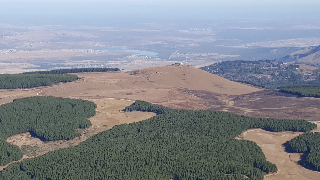
Looking down on Tor Doone from Giakaskop

The top of Giakaskop

Giakaskop trig beacon

Campsite at Swallowtail

A view of Hog 1 over the dam


